Friday, October 31, 2008

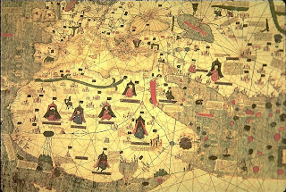
Catalan-Estense Map, 1450-60


Catalan-Estense Map, detail: Asia, Eastern Africa, Middle East


TITLE: Catalan-Estense World Map


DATE: 1450-1460


AUTHOR: unknown


DESCRIPTION: The oldest of the portolan [nautical] charts to survive are of Italian origin, made at Genoa and Pisa; those dating from the latter half of the 14th century are mainly Catalan. But the typical Catalan map is not strictly speaking a portolan chart. It is more than that; for while the latter is essentially a sailing guide concerned with coast wise navigation, the Catalan map is really a world map built up around the portolan chart. It is true that in some cases the term 'world' connotes simply the habitable earth as known by the author, nevertheless, in others, as the Catalan-Estense map, it is interpreted to include lands not yet discovered, but only posited. This aggravated the cartographer's task very considerably for it meant that he was continually being faced with the problem of choosing between scanty and often poorly substantiated fact on the one hand, and plausible and often well-attested theory on the other. It is a tribute to the integrity of these men that their work contains so much that subsequent investigation has proved true. In fact it is this careful sifting of evidence that constitutes one of the chief merits of the Catalan school of cartography, in an age when intellectual honesty was none too common. The value of the Catalan maps, as commentaries upon the state of contemporary knowledge at once becomes apparent and we are hardly surprised to find that the Catalan Atlas of 1375 has the finest delineation of Asia the world had seen up to that time, or that, in its knowledge of Cathay [China] and the Sudan, the same map is surpassed in the Middle Ages only by the 1459 Fra Mauro map. all of approximately the same date, ca.1450. According to Kimble, there are at least three distinct influences, in addition to the portolan chart tradition, that can be detected. These influences are Classical, Christian and Arab. Of these only the Arab influence is strong, while it is improbable that the Classical influence was direct. Thus, in the case of the Catalan-Estense map, it owes nothing to the Ptolemaic tradition, and it is less likely that its author should have taken his idea of a southern continent direct from Crates, the originator of the concept (150 B.C.),

than that he should have taken it from Arab or Christian cosmographers, such as Abu'l Fida or Isidore, who revived it. The influence of the medieval Christian tradition on the Catalan-Estense map is betrayed in such elements as the legend relating to Prester John and the portrayal of the Terrestrial Paradise . There can be no mistaking the Arab influence. We have only to compare the delineation of the southern half of Africa on the map with the description given by the 11th century writer, Al-Biruni, of the shores of the Southern Ocean to be convinced of the kinship. Thus, the Catalan-Estense map, although embellished with castellated towns, ships and portraits of African princes, attempts to furnish an up-to-date picture of the world and to resolve the ancient riddle of Africa nondum cognita.

The circular Catalan-Estense map, measuring 113 cm in diameter, is very colorful with a large number of princes shown throughout Africa (where Prester John has been placed), 52 legends, castellated towns for major settlements, loxodromes, ships, mermaids, domesticated reindeer and horses. Although almost a hundred years later, it is clearly related to the pivotal Catalan Atlas of 1375. This resemblance in the content of the two maps strengthens the contention that the latter was derived from a circular prototype. The nomenclature and the numerous legends on the Catalan-Estense , mostly in Catalan with a few in corrupt Latin, are often very similar to those of the 1375 Atlas . In some instances the legends are more complete, in others they are less detailed; they suggest, therefore, not direct copying but possibly a common source. This similarity is also evident in the delineation of the main features, most of those in the 1375 Atlas are to be found on the Estense map.

The northern portions of Asia and Europe on the Estense map, which lay outside the limits of the Catalan Atlas , significantly, contain very little detail. On the southern coastline of Asia there are some differences, generally slight, between the two maps. The peninsula of India is much less pronounced on the Catalan-Estense map, and to the south is the large island of Salam or Silan [Ceylon/Sri Lanka] which also fell outside the physical limits of the Catalan Atlas . A legend refers to its wealth in rubies and other precious stones. There can be no doubt however that the two outlines are fundamentally identical. To the east is the island of Java, as on the Catalan Atlas . The island of Trapobana is much enlarged, and is placed on the southeastern margin of the map. The surrounding ocean, the Mar deles indies is filled with numerous nameless and featureless islands.

Africa occupies most of the southern half of the map. The continent ends in a great arc, conforming to the circular frame of the map, and extending eastwards to form the southern boundary of the Indian Ocean. On the west, a long narrow gulf from the circumfluent ocean almost severs this southerly projection from northern Africa. The southern interior is blank save for the legend Africa begins at the river Nile in Egypt and ends at Gutzola in the west: it includes the whole land of Barbaria, and the land in the south. This outline and legend have been interpreted to imply some knowledge of the southern extremity of Africa, and perhaps of a practicable route from the west to the Indian Ocean.

That the great western gulf reflects some knowledge of the Gulf of Guinea is more probable. The design of the northern half of the continent in general resembles that of the other Catalan charts, but the northwestern coast embodies some details of contemporary Portuguese voyages as far as C. ude [Cape Verde] and C. groso . From this evidence, the map is usually dated about 1450. Near the gulf are the Mountains of the Moon , from which five rivers flow northwards to a lake on the western Nile . This lake probably represents the area around the Upper Niger liable to inundation; Kimble has pointed out that these rivers may well represent the five main sources of the Niger. These Mountains of the Moon are stated to be on the Equator, and the streams are called the riu de lor . We may therefore assume that the headwaters of the Niger marked the approximate limit of contemporary knowledge in this region, and it is not improbable that reports of the sea to the south had been received. These may have induced the cartographer to accept the western gulf of Ptolemy, but to enlarge it considerably. Again, the name Rio del Oro [river of gold] recalls the inscription on the Catalan Atlas and the classical tradition. The portrayal of the interior thus goes back at least to 1375. Apart therefore from a small portion of the coastline, the map owes nothing to Portuguese exploration.

Some surprise has been expressed that a map of 1450 should contain relatively up-to-date details coupled with antiquated ideas in other areas, and this has produced some rather involved explanations. Taking into consideration the lack of details and names in the southern regions of Africa, we may plausibly conjecture that, as an exception to the usual conservatism, the draftsman, in Africa at least, had removed all the detail for which he had no evidence, to obtain a framework on which to insert the latest Portuguese discoveries. It must remain debatable whether the outline of the southern extremity represents some knowledge of the Cape. The outline may be entirely imposed by the frame of the map: at the most, it may reflect the kind of report that we find on Fra Mauro's map .

The merit of the Catalan cartographers lay in the skill with which they employed the best contemporary sources to modify the traditional world picture, rarely proceeding further than the evidence warranted. In the same spirit they removed from the map most of the traditional fables which had been accepted for centuries, and preferred, for example, to omit the northern and southern regions entirely, or to leave southern Africa a blank rather than to fill it with the Anthropagi and other monsters which adorn so many medieval maps. Though drawings of men and animals still figure on their works they are in the main those for which there was some contemporary, or nearly contemporary, warrant; for example, Mansa Musa , the lord of Guinea, whose pilgrimage to Mecca created a sensation in 1324, or Olub bein , the ruler of the Tatars. In this spirit of critical realism, the Catalan cartographers of the 14th century threw off the bonds of tradition, and anticipated the achievements of the Renaissance.


LOCATION: Biblioteca Estense, Modena, Italy

REFERENCES:
*Bagrow, L., History of Cartography, plate XLIII.
*Cardini, F., Europe 1492, p. 208 (color).
Crone, G.R., Maps and Their Makers, pp. 47-50.
*Destombes, M., Mappemondes, A.D. 1200-1500, pp. 217-221, plate XXXIII.
*George, W., Animals and Maps, pp.13, 39-43, 48-49.
*Gross, J., Mapmakers' Art, p. 45 (color)
*Kimble, G.H.T., Geography in the Middle Ages, pp. 113, 182-3, 194-197.
*Skelton, R.A., The Vinland Map and the Tartar Relation, pp. 113, 118-19, 127, 131, 250, plate XI


Thursday, October 30, 2008

Ellora


Kailasanatha Temple, (Cave 16) view from the top of the rock


Like Ajanta, Ellora in India is the location of a series of cave temples hewn into the living rock. It is located 80 kilometers (48 mi.) southwest of Ajanta. There are 34 individual temples extending along a distance of two kilometers (1.2 mi.). Twelve of these are Buddhist, 17 are Hindu, and five are Jain. The Buddhist temples, which date between 200 B.C.E. And 600 C.E., include sanctuaries and monasteries, with sleeping areas for monks cut into the rock. The most remarkable Hindu structure is the Kailasanatha temple. It is one of the world’s largest statues, because by removing more than 200,000 tons of basaltic rock, the makers created a highly decorated free-standing monolith. Its inspiration lay in the recreation of Mount Kailasa, the home of SIVA. Its construction falls in the reign of King Krishna I (c. 756–773). It is 50 meters long by 33 wide, and it stands to a height of 30 meters (165 by 109 by 99). Remarkably, it is covered in carvings depicting scenes from Hindu epics, including the demon Ravana shaking Mount Kailasa. A contemporary copperplate Inscription described it as “compelling the admiration of even the celestials, who pause on their heavenly course to gaze at the beauty of so magnificent a monument, and wonder how anyone could create such an extraordinary structures.”

#

Kailash Temple Maharashtra


At Ellora , 34 cave temples were carved out of the hillside with hand tools. Only 12 of these 34 caves in the centre are the most impressive. The massive Kailash Temple (cave 16) is nearly one a half times taller than the Parthenon and occupies almost twice its area. It is believed that it was constructed by excavating approx. 200,000 tones of rock and is possible the world's largest monolithic structure. Representing Shiva's Himalayan home, the temple is exquisitely sculpted with scenes from Hindus mythology, each pulsing with drama, energy and passion. The Kailash Temple situated near the village of Ellora. It is considered as one of the most astonishing 'buildings' in the history of architecture. This temple is the world's largest monolithic structure carved from one piece of rock and the rock-hewn temples and monasteries of Ellora that lies just 30 kms from Aurangabad.. Kailash Temple at cave 16, were a big Shiva-linga (form of Lord Shiva) is worshiped. It is the biggest building carved in a stone in the whole world. is a part of Ellora Cave Complex. The Kailasanatha temple is the world's largest monolith structure that was literally scooped out of the hill side. Lord Shiva is worshipped in the form of a giant lingam in the garba griha. Beautiful sculptures from Ramayana and Mahabharatha are carved on the walls of this cave temple.

History


The depiction of the demon Ravana shaking Mount Kailash is a masterpiece contain the scenes of semi-mythological history, the royal court and popular life of the ancient times, as told in romances and plays. Some pictures recall the Greek and Roman compositions and proportions, few late resemble to Chinese manners to some extent. But majority belongs to a phase which is purely Indian as they are found no where else. These monuments were constructed during two different periods of time separated by a long interval of four centuries. The older ones were the product of last to centuries before Christ and belongs to Hinayana period of Buddhism in later part of 2nd century AD when Buddhism was divided into two sections, after the conduct of the fourth general council under another great king, Kanishka.


The new feature of Mahayana Buddhism was the concept of future Buddha's. The Buddha, himself probably thought that he was the last of the long succession of earlier Buddha's who lived before him. According to the Buddhist traditions, these former Buddhas were revered even in the historical Buddha's lifetime. By the time king Ashoka, their cult was widespread and was patronized by Ashoka. Later, when the stupas were constructed and beautified, the carvings were executed in a symbolic way. An inspired sculptor began to carve images of Buddha himself and within the few generations, all the Buddhist sects took to worshiping images. The universe of Mahayana contains numerous Bodhisattava, the chief of whom is Avalokitesvara with attributes of compassion. He is also called Padmapani or the lotus bearer. The Manjushri with a naked sword in one hand, stimulates the understanding. The sterner Bodhisattava who is a foe of the sin and evil and bearing a thunderbolt in the hand is Vajrapani. The future Buddha, Maitreya will take birth to save the world.


Architecture


It is believed that work on the Kailasha temple was begun in the mid-8th century and under the direction of King Krishna I (757-775) of the Rashtrakutadynasty, the rulers of the western Deccan area. One of the India's greatest architectural treasures, was hewn out of the solid rock of the hillside to form a free-standing temple consisting of a gateway, two-storied halls and the main shrine within. The most majestic creation is the Kailash Temple, a full-sized freestanding temple flanked by huge elephants all carved from solid rock, pillars and podiums, as the workers dug away some 200,000 tons of rock. The result is an awe-inspiring representation of Shiva's Himalayan abode. Nearby caves are alive with stone murals depicting divine struggles and victories. With these caves before us, it is clear that India far surpasses the rest of the world in the glory of its rock-cut architecture.


LINK


Further reading: Burgess, J. Cave Temple of Ellora.

Columbia, Mo.: South Asia Books, 1999; Malandra, G. H.

Unfolding a Mandala: The Buddhist Cave Temples at Ellora.

SUNY Series in Buddhist Studies. New York: State University of New York, 1993; Pant, P. Ajanta and Ellora: Cave Temples of Ancient India. Columbia, Mo.: South Asia Books, 1998.

Wednesday, October 29, 2008

The Nubian Pyramids

The Nubian Pyramids

By Kelly Smith


A Map of Nubia (The Sudan)
The history of Nubia, the land south of Egypt, often in conflict with Egypt, frequently under at least partial control of Egypt and late in history, in control of Egypt, is an integral part of Egyptian history. When Egypt was strong, and expanding its territory, it often did so into Nubia, but when Egypt was weak, Nubian territory grew to the north.

Nubia was known to the Egyptians as Kush. During the Middle Kingdom, its principal town was Kerma, which lies just below the Third Cataract of the Nile River. It was ruled by chiefs, or kings who the Egyptians of the Middle Kingdom evidently viewed as a threat, for the Egyptians built a series of fortresses in Northern Nubia to protect Egypt's borders.

During Egypt's New Kingdom, the empire period, Nubia was for the most part a province of Egypt, ruled by the "King's Son of Kush". The southern limits of this control may have been Gebel (mountain of) Barkal, where a Temple of Amun was situated. Then, as the New Kingdom waned and Egypt declined into rival principalities, Egyptian control of Nubia was once more lost. For almost two centuries after the end of the New Kingdom, we find very scant records of Egypt's southern neighbor.

Then, a new Kushite kingdom suddenly appeared, not surprisingly at a time when Egypt was at her weakest. As early as 770 BC, a powerful ruler named Kashta arose out of Napata, located at the foot of Gebel Barkal, to take control not only of Lower, or Northern Nubia, but also of
The Pyramid Field at el-Kurru
Upper, or Southern Egypt as far north as Thebes. There, he had his sister installed as "Divine Adoratice of Amun", a position that had become as important, if not more so, than High Priest. While the people of Thebes acknowledged Kashta as King of Upper and Lower Egypt, it would be his successor, Piye (Piankhi), who would truly rule a more or less complete Egypt. He left behind remarkable documents at Karnak, Memphis and Gebel Barkal, though only the last survives, that casts himself in the traditional role of Pharaoh, the restorer of order against the forces of chaos.

After taking control of most of Egypt, Piye set out for Heliopolis to worship the sun god and celebrate his coronation as king of Egypt. There we are told that he:

"...stood by himself alone. Breaking the seals of the bolts, opening the doors; viewing his father Re in the holy Pyramidion House; adorning the Morning Bark of Re and the Evening Bark of Amun."

Afterwards, he returned to Napata where he founded a Nubian dynasty, Egypt's 25th, that would last for about a century. Upon his death, he became the first Egyptian king in 800 years to be buried in a pyramid. He built it at el-Kurru, about thirteen kilometers downstream from the Temple of Amun at Gebel Barkal, and his was the first of an estimated 223 pyramids that would be built in Nubia over the next thousand or so years. We think that his palace may have been located nearby, though it has never been unearthed. Between 1918 and 1919, George Reisner conducted excavations at el-Kurru, but by then only one pyramid was still standing. He found
Plan and Sectional of Piye's Tomb at el Kurru
under low mounds of rubble the tombs of Piye and his successors of the 25th Dynasty, Shebaka, Shebitku and Tantamani. Their tombs had once been covered by pyramids, but by the early 20th century, they had been entirely removed.

These pyramids bore much more in common with the private ones that can still be found on the West Bank at Thebes (modern Luxor) than with the Great Pyramids of northern Egypt, though it is commonly assumed that he was inspired by the latter. Even though the superstructure of his own tomb had been removed, its foundation trench indicated a pyramid with a base length of only about eight meters, and a slope of probably about 68 degrees. Nineteen steps led down from the east to the burial chamber that was cut into the bedrock as an open trench and covered with a corbelled masonry roof. Piye's body had been placed on a bed that rested in the middle of the chamber on a stone bench with its four corners cut away to receive the legs of the bed, so that the bed platform lay directly on the bench. This was probably a Nubian custom, though fragments of canopic jars were discovered, leading Egyptologists to believe that he was most likely embalmed in Egyptian style. There were also the remains of Shabti figures, more typically found in Egyptian tombs. There had been a chapel built over and covering the stairway to the burial chamber, but it too was completely destroyed.

The pyramid of his successor, Shebaka, had a similar layout although the burial chamber was completely subterranean, and included a vaulted ceiling cut in the natural rock. Here, the entrance to the pyramid itself was built far enough to the east to allow it to be entered after the mortuary temple was built. A stairway led down to a short tunnel that than led into the burial chamber.

Along with the kings of the 25th Dynasty, there were also fourteen queens' pyramids built at el-Kurru, measuring between six and seven meters square, actually only slightly smaller than the kings' pyramids, which measured from eight to eleven meters square.

Reisner also found the graves of 24 horses and two dogs nearby. Four of the horses belonged to Piye, and four more to Tantamani. Scholars speculate that they may have each belonged to a chariot team. There were also ten horses belonging each to Shebaka and Shebitku. All of the animals had been sacrificially decapitated, and their skulls were missing. They were each buried in a standing position, and their bodies were draped with beaded nets hung with cowrie shells and heavy bronze beads. They also had silver collars and gilded sliver plume holders. There is also some speculation whether these horses might correspond with the boat burials of earlier pyramids.


Plan and Section of the Pyramid of Taharqa at Nuri
One of the last kings of the 25th Dynasty, Taharqa (known in the bible, Kings 19:9, as Tirakah), moved to Nuri, a site just on the other side of the river from Gebel Barkal, to build his pyramid. There, he built a much larger pyramid measuring some 51.75 meters square with a height of between 40 and 50 meters. It was the largest pyramid ever built at Nuri, and is unique among the Nubian pyramids in having been built in two stages. The first pyramid was encased in smooth sandstone. Drawings and written reports of the early 19th century reveal the truncated top of the inner pyramid projecting from the top of the decaying outer pyramid. The outer pyramid was the first of a type with stepped courses and planed corners. It had a sloped angle of about 69 degrees. An enclosure wall tightly encircled the pyramid, but Reisner was not able to unearth any traces of a chapel.

However, the subterranean chambers of this pyramid are the most elaborate of any Nubian tomb. The entrance was by way of an eastern stairway trench, north of the pyramid's central axis, but in alignment with the original smaller pyramid. Three steps led down to a doorway with a molded frame and cavetto cornice. The doorway then led to a tunnel that widened and opened into an antechamber with a barrel-
Some of the surviving pyramids at Nuri
vaulted ceiling. Six huge pillars carved from the natural rock divided the burial chamber into two side aisles and a central nave, each with a barrel-vaulted ceiling.

Though a rectangular recess was cut into the floor of the burial chamber for a sarcophagus, no sarcophagus was found. In addition, there were four rectangular niches in the north and south walls and two in the west wall. The whole of the chamber was surrounded by a moat-like corridor that could be entered by way of steps leading down from in front of the antechamber doorway. Another set of steps led to the corridor from the west end of the nave. Indeed, the whole arrangement is not unlike the Osireion, a symbolic Osiris tomb built by Seti I at Abydos.

During the reign of Taharqa, the Assyrians were becoming a growing threat. In fact, his successor, Tantamani, after having briefly received the submission of all the Egyptian Delta
The pyramid field of Nuri plan layout
rulers, was then forced back by the Assyrians to Napata. Nubian rule of Egypt gradually came to and end as Psamtik I, an Egyptian under Assyrian control, consolidated his powerbase in Egypt. Nevertheless, Tantamani and his successors would rule a territory that extended from the First Cataract (at Aswan) south to the White Nile for the next 350 years.

Though Tantamani returned to el-Kurru to build his pyramid, 21 kings and 53 queens and princes were buried at Nuri under pyramids built of good masonry, using blocks of local red sandstone. In general, they were all much larger than those at el-Kurru, reaching heights of twenty to thirty meters. They had mostly consistent plans, with chapels built against the eastern faces decorated with reliefs and a stela built into the pyramid masonry depicting the king before the gods. The substructures almost always include stairway trenches to the east of the chapels that gave access to chambers, including two or three rooms, which were sometimes inscribed with the "Negative Confession" from the Egyptian Book of the Dead.

Their burial practices were largely Egyptian. They were mummified in Egyptian fashion, and their burials included multiple shabtis (some 1070 in Taharqa's pyramid alone). The royal mummies were adorned with gold jewelry, green stone heart scarabs, gold chest pectorals and gold caps on on the fingers and toes. The kings were also equipped with crooks and flails. The coffins were anthropid, made of wood and covered with gold leaf and inlaid with colored stone. There were sometimes outer coffins that were even more elaborate, covered with gold and stone inlays with the motif of falcon and vulture wings. Several bodies of kings, notably those of Anlami and Aspelta (about 568 BC), were placed in huge granite sarcophagi. Aspelta's in particular weighed 15.5 tons and had a lit weighing four tons, carved with Pyramid Texts, chapters form the Book of the Dead, and depicting various Egyptian gods.

The Nubian pyramid field at Nuri continued to receive the bodies of the royalty until about 308 BC. Afterwards, the site of Meroe, further south between the Fifth and Sixth Cataracts rose to prominence as a royal cemetery. No evidence has really surfaced about why this transfer was made, though there is some speculation that the Meroe may have slowly gained importance beginning as early as 590 BC, after Psamtik II campaigned in northern Nubia. He may have defeated King Aspelta's army and marched on Napata, but much of this is very uncertain.

In fact, Peter Shinnie, one of the excavators at Meroe, has pointed out that no settlement has ever been found at Napata (near Nuri), and no royal residence may have ever been located at that site. On the other hand, Meroe was settled as early as the 8th century BC. It may have predated Napata, and even been the cultural and political center all along. At any rate, it provided a somewhat more comfortable cushion of land separating it from Egypt.

Meroe would remain the royal cemetery for 600 years, until about 350 AD. The main heartland in this area, known today as Butana, was better known to ancient writers as the "Island of Meroe". It is bounded on three sides by the rivers Nile, the Atbara and the Blue Nile. Most traffic from Napata to Meroe, however, took the road along the Wadi Abu Dom that cuts across the great bend of the Nile from the Fourth to the Sixth Cataracts. Meroe was repeatedly a refuge for Napatan and Meroitic kings when they retreated from world powers who penetrated down the Nile. It lay just beyond the reach of the Roman Empire, with which it was tied economically through trade.

The Pyramid Fields of Meroe in Nubia (The Sudan)

Some writers have described Meroe as one of the largest archeological sites in the world. The actual settlement of Meroe is just about one half mile east of the river and its cemeteries lie in the desert somewhat farther east. The first known, major king to build his tomb at Meroe was Arkamaniqo (sometimes referred to as Arikakaman, known to Diodorus as Ergamenes). He
Two Pyramids at Meroe restored by F. W. Hinkel
ruled at about the same time as Ptolemy II in Egypt. His pyramid was built in the South Cemetery, which had actually been in use since the time of Piye. There were as many as three kings buried here, including Yesruwaman and Kaltaly, as well as six queens, but the crowding caused by more than 200 individual graves prompted future royalty to move across a narrow valley to a curving ridge, where they initiated a North Cemetery. As many as 30 kings may have been buried in the North Cemetery. A third cemetery at Meroe, known as the West Cemetery, includes brick-faced and rubble pyramids of lesser royalty surrounded by a host of graves, many of which are well furnished, belonging to important private households of Meroe.

Like Nuri, these pyramid are fairly standardized. They are all steep-sided pyramids built of sandstone, with a height between ten and thirty meters. As at Nuri, they are stepped and built on a plinth, though here each triangular face was framed by smooth bands of raised masonry along the edges where the faces meet. Note that the pyramids at Gebel Barkal also have this feature.

Where the upper parts of the pyramids are preserved, these lines are rounded, like the torus
Pyramids of Meroe with their pylon-like Chapel Entrances
moldings on the corners of Egyptian temples, for the upper fourth of the total pyramid height.

Against the eastern side of the pyramids was situated a chapel, often fronted by miniature pylons.

Towards the end of the Meroitic period, the pyramids are no longer stepped, but smooth and the casing blocks become much smaller laid on a poorly constructed core. In fact, the last of these pyramids were built of rubble and brick and had a plastered surface.

For the substructure, they have an eastern stairway descending to a blocked doorway in front of usually three adjoining chambers. Normally, two of the chambers had square pillars carved from natural rock, with a third, innermost smaller chamber. Ceilings were slightly vaulted in earlier chambers and more roughly hewn, round vaulted in later ones.


More Pyramids of Meroe
At Meroe, the body of the deceased was buried in the innermost chamber in a wooden anthropoid coffin placed on a raised masonry bier. The finer ones were carved with divine figures. Relief scenes in the chapels attached to the pyramids, including depictions of mummies and the remains of canopic equipment, suggest that at least the royal bodies were still mummified. Excavations unearthed bodies that were adorned with gold and silver jewelry, along with bows, quivers of arrows, archers' thumb rings, horse trappings, wood boxes and furniture, bronze lamps, bronze and silver vessels, glass bottles and pottery. The chamber nearest the entrance often contained wine amphorae and food storage jars.

Here, and elsewhere in Nubia, kings and even wealthy commoners also took with them to their graves servants who were apparently sacrificed at the time of their master's funeral. Animals, including yoked horses, oxen, camels and dogs were also slaughtered and interred outside the entrances of the burial chambers.

A famous treasure, known as the Ferlini Treasure named for its discoverer, the Italian explorer, Giuseppe Ferlini, was unearthed in 1830 in one of the North Cemetery Pyramids (Beg. N.6). This was the pyramid of Queen Amanishakhto who lived during the late 1st century BC. Ferlini reported that this cache of gold rings, necklaces and other ornaments was found in a secret chamber at the top of one of the pyramids, with obvious results. Soon, other treasure hunters
Plan and Section of the Meroe Pyramid Beg N.6
were lopping off the tops of the other pyramids. In fact, the treasure was almost certainly found in one of the subterranean chambers.

The re-emergence of the royal pyramid after some 800 years is an interesting case of the transfer of an architectural, as well as a religious idea from one region and culture to another. It seems that the Nubians, for a considerable period of time, probably had a rather high regard for their neighboring culture to the north. When Egypt floundered, the earlier Nubian kings who took control of Egypt sought to turn back time to a more classical Egyptian past, and they took some of this past home when they left Egypt.

The Nubian pyramids are characterized by smaller scale, with steeper slopes, but they are far more numerous, considerably more standardized and owned by more members of the royal households (and probably non-royals as well) than the classical Egyptian pyramids. When the Nubians stopped building them, the pyramid as a marker for a royal tomb would be no more.

Resources:

Title

Author

Date

Publisher

Reference Number

Complete Pyramids, The (Solving the Ancient Mysteries)

Lehner, Mark

1997

Thames and Hudson, Ltd

ISBN 0-500-05084-8

Illustrated Guide to the Pyramids, The

Hawass, Zahi; Siliotti, Alberto

2003

American University in Cairo Press, The

ISBN 977 424 825 2

Oxford Encyclopedia of Ancient Egypt, The

Redford, Donald B. (Editor)

2001

American University in Cairo Press, The

ISBN 977 424 581 4

Pyramids, The (The Mystery, Culture, and Science of Egypt's Great Monuments)

Verner, Miroslav

2001

Grove Press

ISBN 0-8021-1703-1

Treasures of the Pyramids, The

Hawass, Zahi

2003

American University in Cairo Press, The

ISBN 977 424 798

GEBEL BARKAL


The pyramids of Gebel Barkal by Ernst Weidenbach, 1845


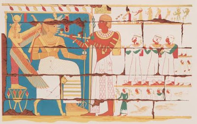
Pharaoh and a Temple Chantress present offerings to Amon-Re. The lady on the left wears the crown of Lower and Upper Egypt. Art from Gebel Barkal, by Ernst Weidenbach, 1845.

Incense and gifts for Pharaoh, protected by winged Isis. Artist uncertain, perhaps Weidenbach.


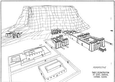
Reconstruction of the Gebel Barkal temples.


Gebel Barkal, on the western edge of modern Karima, Sudan, is an isolated sandstone butte 1km from the right (northwest) bank of the Nile and about 20km downstream from the Fourth Cataract in Upper Nubia (18°32' N, 31°49' E). Triangular in outline, the mountain is about 1km in circumference, rises 102m from present ground level, and faces the river with a sheer cliff 93.06m high. Marking the location of the ancient city of Napata, it is bounded on the southeast by a huge cult precinct and on the west by an ancient cemetery, including royal pyramids. Described in the early nineteenth century by George Waddington and Barnard Hanbury, Frédéric Cailliaud, Louis Linant de Bellefonds, George Hoskins, John Lowell, Richard Lepsius and John Gardner Wilkinson, among others, the site was briefly excavated in 1897 by E.Wallis Budge for the British Museum and in 1907 by James Breasted for the University of Chicago. The first major excavations were undertaken by George Reisner and his Harvard University-Museum of Fine Arts (MFA) Boston expedition from 1916 to 1920. These investigations have been followed more recently by an expedition of the University of Rome, under F.Sergio Donadoni (1972 to present), by a renewed expedition of the MFA under Timothy Kendall (1986 to present) and, from 1996, by an expedition of the Fundacion Clos, Barcelona, in the Barkal cemetery.


From at least the 18th Dynasty, Gebel Barkal was identified as a sacred hill. The Egyptians declared it the chief Nubian residence of the Theban god Amen, and for this reason they called it “The Pure Mountain” ( ) and “Thrones [or Throne] of the Two Lands” (Nswt [or Nst]-T3wy): or the source of Amen’s most ancient epithet (Lord of the Thrones of the Two Lands). The name “Napata” (Npt) is thought to have been derived from the word ipt (sanctuary, forbidden place), and the god worshipped here, by the 19th Dynasty, would come to be called “Amen of Napata,” or, by Meroitic times, “Amanapa.”


The Egyptians, and perhaps the earlier Nubians as well, attached religious significance to the mountain because of the unusual freestanding pinnacle on its southwestern corner. Viewed from different angles, this statue-like, natural rock formation appeared to them variously as (a) a uraeus (sacred cobra) wearing the White Crown of Upper Egypt, (b) a uraeus wearing a sun disk, and (c) an erect phallus, evocative of the procreative forms of Amen/Re-Atum. The mountain came to be seen not only as a primeval source of creation, but also as the original home of the sun god’s uraeus (the “Eye of Re”) and the king’s uraeus, and thus an important source of kingship.


Pottery of the Neolithic, Pre-Kerma and Kerma periods has been found on or beside the mountain, indicating that the site probably had been continuously occupied long before the Egyptians conquered Upper Nubia in the early 18th Dynasty. A cave site on the western cliff of Gebel Barkal was apparently frequently visited in pre-18th Dynasty times as a source of the fine white clayey material kaolinite. The earliest evidence of Egyptian settlement and building activity is from the reign of Tuthmose III. His stela at Gebel Barkal, dated to his 47th regnal year, is the first to mention Gebel Barkal by name and to refer to an existing native settlement and a newly built Egyptian fort called “Repelling the Foreigners.” The fragmentary stela describes a miracle by which the Egyptians identified the mountain with Amen, although there is reason to believe that the Egyptians may have identified a ram-headed local Nubian god as an alternate form of their own supreme god and to have simply taken over a pre-existing sacred place.


Tuthmose III built the first Amen sanctuary (labeled B 500-sub by Reisner) at Gebel Barkal. The stela at Amada of Amenhotep II is the first to record a town here called Napata, from whose “walls” a Syrian chief was said to have been hung. Temple building activity continued under Tuthmose IV, who added temples B 700-sub, B 600-sub and B 300-sub. During the Amarna period (reign of Amenhotep IV/Akhenaten), the name of Amen was methodically erased from local monuments, revealing that the king even attempted to eradicate the local cult in Nubia. It was restored, however, under Tutankhamen and Horemheb, who erected the nucleus of temple B 500. This temple was greatly enlarged in the 19th Dynasty by Seti I and Ramesses II, with the addition to it of a hypostyle hall (B 502), probably of 72 columns. After Ramesses II’s reign all evidence for building activity ceases, and the temples appear to have fallen into ruin and disuse until the advent of the earliest Napatan monarchy (circa 850–800 BC).


The Amen cult and sanctuary at Gebel Barkal were revived by the native Nubian kings buried at nearby el-Kurru. Why they became adherents to the Egyptian cult of Amen remains unclear, but one theory suggests that their conversion may have been brought about by expatriate Theban priests, fleeing persecutions caused by civil disturbances in Upper Egypt at the end of the 22nd Dynasty. The earliest Napatan temple (B 800-sub) was of mudbrick with stone columns, and this can almost certainly be attributed to Alara (circa 785–760 BC), the first Napatan king known by name. Its stone extension, as well as the lowest level of the adjacent Napatan palace (B 1200), can be attributed to his successor, Kashta (circa 760–747 BC), the first Kushite king to reign also in Egypt. His son Piye (circa 747–716 BC) refurbished the old Egyptian temple B 500, first encasing it in new masonry and adding new rooms, then later restoring the hypostyle hall (B 502) with 46 columns and adding a new outer court (B 501). He also refurbished B 800 in stone. These parallel Amen temples are presumed to have been dedicated to Amen of Napata and Amen of Karnak, respectively, since each god was said to have conferred upon the Kushite kings a half part of their kingship. Piye’s son and third successor, Taharka (circa 690–664 BC), added temples B 200 and 300, dedicated to the goddesses Hathor, Mut, Tefnut and Sekhmet, who were all aspects of the “Eye of Re,” manifested in Gebel Barkal’s uraeiform pinnacle beneath which the temples were built. He also placed a statue and inscription, covered with gold sheet, on the summit of the pinnacle.


Tanutamei (circa 664–553 BC), the last Kushite ruler of Egypt, contributed a kiosk (B 502) inside B 500. His successor Atlanersa (circa 653–643 BC) started construction on the smaller temple B 700, but died before it was completed, leaving the work to be finished by his heir Senkamenisken (circa 643–623 BC). This temple seems to have been dedicated to the Osirian aspects of Amen, as well as to the Nubian god Dedwen, and all deceased kings; its bark stand is now in the MFA, Boston. B 800 and 1200 were again restored during the reign of Anlamani (circa 623–600 BC); the latter was completed by Aspelta (circa 600–580 BC). Shortly afterward the temples and palace were burned, and the many royal statues in B 500 were pulled down and vandalized. This, and contemporary damage noted at other Napatan sites, is almost certainly to be attributed to the invasion of Nubia by the army of Psamtik II (26th Dynasty) in 593 BC.


Although this destruction may have been a primary cause of the move of the Kushite court to Meroe, the Gebel Barkal sanctuary seems to have been restored during the sixth century BC. Unfortunately, no royal names can yet be connected with this restoration. In the early fourth century BC Harsiotef again restored B 800, B900 and the palace B 1200, and Nastasen restored Taharka’s pinnacle monument, adding his own name to it. Both Harsiotef and Nastasen also set up stelae at Gebel Barkal detailing their works at the site, works that can no longer be traced in the archaeological remains. Following a probable final restoration of B 1200 by Amenislo (circa 260–250 BC), a new palace (B 100) was erected about 75m in front of the former during the second century BC.


The rock ledges of Hillet el-Arab, immediately southwest of Gebel Barkal, were evidently used continuously as a burial place beginning in the New Kingdom; they are honeycombed with rock-cut tombs and are presently being excavated by a joint Sudanese and Italian Mission under Irene Vincentelli-Liverani. The desert area immediately west of Gebel Barkal was also a cemetery, probably as early as the 25th Dynasty, and a ruined royal tomb, recently discovered by the archaeological mission of the Fondacion Clos, apparently belongs to the mid-sixth century BC. Again, in the early third century BC, a king, perhaps Arnekhameni, selected the site for his pyramid tomb and those of his several queens. While his immediate successors preferred to build their tombs at Meroe, more royalty erected their pyramids at Gebel Barkal during the second and first centuries BC.


Prior to the second century BC, the Gebel Barkal sanctuary seems to have been centered primarily in an arc around the pinnacle, with its western extremity marked by B 200 and its eastern by B 1700, the yet unexcavated temple bakeries. Later, however, when Meroe was the capital of the Kushite state, there was a massive new development of the area northeast of B 1700. Several new temples were built (B 1800–2400), which have not yet been excavated, as well as a large new palace (B 1500), which replaced B 100. B 500 was extensively restored, and a new kiosk (B 551) was added in front of B 501. All of this construction probably dates to the reigns of Amenishakheto, Natakameni and Amenitore, a program very likely undertaken as a result of the reported destruction of Napata at the hands of the Roman general Petronius about 24 BC.


Throughout most of the history of Kush, Gebel Barkal remained the most important religious center of the kingdom, and was for many centuries the primary center for coronations and kingship ritual. After the decline of the Meroitic kingdom (circa AD 350), the site became a Christian village and cemetery.


Further reading

Dunham, D. 1970. The Barkal Temples. Boston.

Kendall, T. 1991. The Napatan palace at Gebel Barkal: a first look at B 1200. In Egypt and Africa: Nubia from Prehistory to Islam, W.V. Davies, ed., 302–13. London.

——. 1997. Excavations at Gebel Barkal, 1996: report of the Museum of Fine Arts, Boston, Sudan Mission. Kush 17: in press.

Reisner, G.A. 1931. Inscribed monuments from Gebel Barkal. ZÄS: 76–100.

Robisek, C. 1989. Das Bildprogramm des Mut-Tempels am Gebel Barkal. Vienna.


LINK


LINK

Tuesday, October 28, 2008

Hamunaptra


A Mythic Vistas Campaign Setting for the d20 System


Written by C.A. Suleiman, with Steve Kenson and Ari Marmell


Boxed Set with 3 Books
ISBN: 1-932442-33-2

Towering pyramids rise from the sands, speaking of the glory of kings long gone. Three mighty pharaohs, kings, and gods, rule over a land divided--over nations hovering on the brink of war. Priests of mighty deities guide the lives of peasants and nobles alike, as all struggle to make the most of the fertile lands that line the mighty river Yor, whose rushing waters are at once the symbol and the source of all life. But all around, the desert grows, encroaching nearer each day to the last remaining refuge of a once mighty civilization.

Egyptian Adventures allows you to play the world's most popular roleplaying game in the sands of Hamunaptra, a new fantasy setting inspired by the myths, legends, and culture of Ancient Egypt. Neither the Egyptian feel nor the playability of the game has been sacrificed. The classes and races that populate the lands of Hamunaptra are still recognizable as your own favorites, yet re-imagined to convey the feel of a time of pharaohs under the shadow of war.

This boxed set includes three separate books, each of which presents vital setting information. From the classes, races, feats, and magic of Hamunaptra, to a complete gazetteer of the continent of Khemti and a book of GM-only secrets, this boxed set contains all you'll need to explore the world of Hamunaptra. Battle foul beasts of the desert, excavate the curse-warded tombs of dynasties past, sabotage and spy upon the armies of rival nations, master ancient magics, or simply attempt to solve the riddle of the expanding Red Land before the desert overtakes the last, dwindling bastions of civilization.

This is an age of legend. Make it your own

Hamunaptra Errata


Book I: Page 18-19
The Sutekhra and Asari pictured on pages 18-19 have their identifying names reversed.

Page 88
Change to the following

Moment of Cunning
Level: Bard 0, sorcerer/wizard 0
Duration: 1 round

Page 89
Moment of Endurance
Level: Cleric 0, druid 0, ranger 1, sorcerer/wizard 0
Duration: 1 round

Moment of Grace
Level: Bard 0, druid 0, ranger 1, sorcerer/wizard 0
Duration: 1 round

Moment of Splendor
Level: Bard 0, cleric 0, paladin 1, sorcerer/wizard 0
Duration: 1 round

Moment of Strength
Level: Cleric 0, druid 0, paladin 1, sorcerer/wizard 0
Duration: 1 round

Moment of Wisdom
Level: Cleric 0, druid 0, paladin 1, ranger 1, sorcerer/wizard 0
Duration: 1 round

Book II: The Book of Gates
Where the "Divination" domain is indicated, replace with "Prophecy" domain.
_________________
Robert J. Schwalb
Game Designer/Developer


Hook Generator

Egyptian Adventures: Hamunaptra


Sunday, October 26, 2008

JOTUNHEIM -RPG


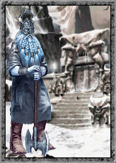
Jotunheim is not a place for the faint of heart. It is the land of the Frost Giants, and that makes it a very dangerous place to begin with. Jotuns are only one of its many hazards, though. It is populated by a variety of deadly monsters, and it is in many respects a frigid wasteland where only the hardiest survive for long. A journey to Jotunheim is a momentous undertaking for a god. For a mortal, it is the mission of a fool.

Geography

Jotunheim is one of the largest of the Nine Worlds. It stretches out for many, many miles, encompassing enough land to span all the nations of Midgard and more. It is eternally winter there, and the whole of the realm is made up of snow-capped mountains, glaciers, and tundra. Jotunheim does experience seasonal change, but summer (such as it is) lasts only for a month and is characterized by temperatures only slightly above freezing. Autumn lasts for about a week — just enough time to alert the denizens to the fact that winter is returning. Spring tends to be longer — usually two months — but it features alternating periods of warming and sudden storms that plunge temperatures back down.

The northern and western edges of the realm are studded with enormous mountains that stretch up into the clouds. These forbidding peaks are home to the castles of the most powerful giant jarls. Huge glaciers run down the mountainsides like rivers of ice emptying out into the frozen tundra of the plains below.

Jotunheim is bordered on the east by a large sea that separates it from Asgard. While small communities of giants do live on the shore, there are no ports or cities providing access to or from the harsh land. The terrain between the tundra and the sea is marked by large rolling hills that are difficult to navigate in bad weather owing to the snow that lifts into the air during storms.

Denizens

Jotunheim is the land of the Frost Giants, but they are not its sole inhabitants. A wide variety of monsters also populate the frozen realm. Generally speaking, any creature with the Cold Subtype can be found in Jotunheim. It also makes a good home for monsters with any mountain in their climate description, though keep in mind that the temperatures are universally cold so only monsters that can thrive under those conditions will be found here.

Size

It’s important to note that everything in Jotunheim is big. It is a land populated by giants, and everything around them is giant as well. Many of the creatures on the random encounter tables have been adjusted in size to reflect this. As a general rule, if you want to use a creature that doesn’t appear on the charts, you should adjust its size up one level to reflect the gargantuan nature of the land of the Frost Giants. A Jotun’s dog is a big challenge for a mortal and can cause some trouble for a god owing simply to its size. Use your common sense since some of the creatures in the game are already meant to be “giants.” In general, though, bigger is definitely better.

This applies to everything about Jotunheim. The trees are like redwoods. The mountains are like Everest. Everything is expansive. A giant’s house is a mansion to a puny mortal or god. A giant’s castle is akin to a city by way of comparison. Don’t forget that the Jotuns are very worthy foes to the gods. Everything about Jotunheim is large and challenging and dangerous.

Saturday, October 25, 2008

Dundrum Castle

Dundrum, or the Magennis Castle, as it may have looked in earlier times.

This 12th-century castle with its circular four-storey high keep was built by the Anglo-Norman knight John deCourcy on the summit and slopes of a 200-foot-high hill, and was the object of frequent struggles between the invaders and the native Irish.The castle was besieged and taken over in 1210 by king John, and it remained in royal possession until 1227, when Henry III made it over to Hugh deLacy the Younger.

The castle occupies a magnificent location, dominating the surrounding countryside and the sea. It is built on a prominent hill of shale and grit, carved out by the ice during the last Ice Age. Bare rock is clearly visible, especially under the gatehouse and in the defensive ditch which surrounds the castle. Situated on the western shore of Dundrum Inner Bay, it commands a fine natural harbour which offered easy penetration inland, especially to the fertile Lecayle peninsula. This strategic importance, recognised by the builders of the early Christian “dún” or fort, which previously occupied the site, and those of the Anglo-Norman castle, was described by Lord Leonard Grey, who took Dundrum in 1538 as: “one of the strongest holds in all of Ireland, and most commodious for defence of the whole countrie of Lecayle both by sea and land, for Lecayle is environed by the sea, and there is no way to enter it by land but by the said castle”. Although one of the delights of the hill is now its tree cover, the surroundings of the castle must have been far more open at the time it was in use, since trees would have provided unwelcome cover for assailants.

via Dundrum Castle

Friday, October 24, 2008

PILBARA ROCKS COULD HOLD CLUES TO EARTH'S ORIGIN


Remnant cores and bands containing filaments.

a, Silica-rich colloform cores containing filaments, surrounded by replacive pyrite (gold). Combined transmitted and reflected light (TL and RL) photographic montage. b, Thin banded layer containing filaments within paragenetically early chert (TL and RL). c, Detail of a showing the partial replacement of quartz-rich colloform structures displaying fine-scale lamination (TL and RL). Scale bar is 1 mm for a, b and 0.1 mm for c.

Western Australia's Pilbara region continues to yield tantalising clues on the origin of Earth's life forms.

Oxygen-producing photosynthesis may not have been around as long as previous studies suggest say Australian researchers, but not all are convinced.

Dr Birger Rasmussen of Curtin University of Technology in Perth and colleagues report their findings in today's issue of the journal Nature.

"Without oxygen we wouldn't have the development of more complex aerobic life - multicellular life. So [its production is] a really important event in earth's history," Dr Rasmussen said.

Nearly a decade ago, co-author Dr Jochen Brocks of the Australian National University in Canberra and colleagues reported evidence of photosynthesis in 2.7 billion-year-old rocks from Western Australia's Pilbara region in the journal Science.

They reported finding "biomarkers", molecular fossils, including hydrocarbons such as hopane and sterane, believed to come from the membranes of photosynthetic cyanobacteria.

This landmark study pushed evidence for oxygen-producing cyanobacteria back by 300 million years and presented scientists with a conundrum, said Dr Rasmussen.

He says it was not until 2.45 to 2.32 billion years that the first major rise in atmospheric oxygen occurred, as recorded in the Great Oxidation Event - a mass oxidation of minerals in the Earth.

"If you had oxygen-producing cyanobacteria at 2.7 [billion years ago] churning out oxygen, why did it take so long - why did it take 300 million years - before we see the results of that?" he said.

The biomarker study also set back the age of the rise of eucaryotes by a billion years - long before the Great Oxidation Event.

All in all it created "a yawning palaeontological divide", says Assistant Professor Woodward Fischer of California Institute of Technology, in a commentary accompanying the new study by Rasmussen and team.

Scientists have spent a lot of time developing models to explain this time lag but now Dr Rasmussen and colleagues say the earlier research got it wrong.

"You may not need an explanation [for the time lag]. It may be simpler than that," he said.

Telltale isotopes

Dr Rasmussen and colleagues have carried out another analysis of Pilbara rocks, including samples used in the biomarker study.

They say that carbon-13 to carbon-12 isotope ratios associated with the biomarkers indicate they are younger than organic residues found in the rocks themselves, and they must have become associated with the rock at a later date.

"The results we've got suggest that the biomarkers were probably not indigenous to the rock they were extracted from," Dr Rasmussen said.

He says about 2.2 billion years ago the rock was heated as high as 200 degrees Celsius and the biomarkers must be no older than this because they are unlikely to have survived the heat.

"They could have entered the rock after that peak heating event, possibly infiltrated from younger sedimentary rock, or even during the drilling process [to obtain rock samples]," he said.

The original team's method involved crushing the rock and dissolving it in solvents, allowing for greater potential for contamination of the sample, whereas the new study analysed organic carbon residues in situ by examining ultra thin slices of the rock.

Not the last word

Geologist Professor Malcolm Walter, who heads up the Australian Centre for Astrobiology at Macquarie University in Sydney, says the latest study has been much anticipated as experts knew there were limitations to the earlier study.

But he says "it's definitely not the last word".

"I'm keeping an open mind on it at this stage," he said.

Professor Walter says there is independent evidence to suggest cyanobacteria was around earlier, including 2.7 to 2. 8 billion-year-old stromatolites found in the same rocks that yielded the biomarkers.

"Those particular stromatolites have characteristics that suggest they were built by cyanobacteria," he said.

Paris 1248 RPG


Thursday, October 23, 2008

CASTELLANY

Motte-and-Bailey Castle


Schematic View of a 14th Century Castle. Such a castle was characterized by height and verticality. (1) Ditch (possibly filled with water) creating an inaccessible zone around the fortress. (2) Gatehouse with portcullis (a large iron or wooden grating used to block the passage when released vertically) and drawbridge (provided with a raising-and-lowering mechanism to hinder or enable passage). (3) Tower, projecting combat emplacement also used as lodging and storage place. (4) Wall, also called “curtain.” (5) Wallwalk protected by a crenelated breastwork on top of the wall. (6) Hoarding, also called “brattice”, a wooden balcony fitted with apertures through which the defenders could throw down missiles on enemies. (7) Postern, or sallyport, a secondary access. (8) Pepperpot turret, a small watchtower or lookout post. (9) Bailey, the open courtyard with chapel, well, stables, and other lodging and service buildings. (10) Dungeon, or keep, the most powerful tower of the castle and the dwelling place of the lord.

In theory the whole feudal pyramid of loyalty culminated in the king. But as the kings— until the 12th century — were rather weak powerless rulers, political power was based almost entirely on force of arms. Anyone prestigious enough to gain followers, able to build a castle, and rich enough to garrison it could create his independent state and concentrate in his own hands military, political, juridical, and economic power within his tiny kingdom. Moreover, the holder of a court of justice gained both authority and income as fines paid by offenders went into his coffer. The working unit of government became thus the castellany — the land near enough to a castle that it could be protected, policed, and administrated by the lord of the castle. In the 10th century, most castles were motte-and-baily fortresses. Based on a Viking/Norman design these were made by digging a ditch and piling the dirt into an artificial motte or mound. The edge of the ditch and the top of the mound were fortified with wooden palisades. On the summit of the mound inside the stockade stood a wooden tower which was the residence of the lord and his household. At the foot of the motte there were shallower and narrower ditches and stockades enclosing a bailey, an area which was a small village with houses and workshops for the lord’s servants as well as stables and other outbuildings. In case of danger the baily served as a place of refuge for the lord’s subjects from the neighborhood: the peasants, their families, and stock.

Siege warfare was then quite primitive. The besiegers could make a blockade all around the castle and wait until the hungry and discouraged assieged would surrender. But if attrition did not work, the attacking party would assault the place. The ditches could be crossed, the palisades scaled. After having conquered the bailey, the aggressors would attack the tower on the motte, breaking the palisade with a battering ram, setting the tower on fire, and launching an assault.

Very few people could read, and as the only artificial light available was from smoky torches, the lord was likely to go to bed right after darkness set in. In peacetime, the feudal lord at home got up at dawn, heard mass in his chapel, and got the daily business done with his officials. Some rich lords might hold many estates a considerable distance apart. If so, they might live in different houses at different times, traveling from manor to manor to ensure that their lordship was recognized and respected; they might also grant a manor with estate in fief to loyal sub vassals.

A king, a duke, a count, or any mighty lord would have a household, a court, and various officials to assist him in ruling. The same men who ministered to the domestic needs of the household conducted the business of the fief and participated in warfare. The provost superintended the demesne and collected taxes and dues. In England the Anglo-Saxons kings appointed a shire-reeve or sheriff, a removable agent in each county. The chaplain heard confession and said mass in the chapel. Since the chaplain was a clerk, he did not fight, and, as he was often literate, he held the lord’s written records. In time he was called chancellor and had other clerks under him who served as chaplains and secretaries. The chamberlain looked after the bed chamber, watched over the lord’s valuables, jewels, and clothes as well as archives and charters, and he generally controlled access to the lord. The constable and the marshal were military officers that commanded the soldiers, were responsible for armor and weapons, and saw to the horses and, as such, had a high status in the feudal demesnes showing the importance of horses. The steward was the head of the administration; he was also responsible for the provisioning of the household. The steward was assisted by the butler, who procured the wine, and the dispenser, who supervised the issuance of wine.

Entertainment included solid meals and drinking and possibly more refined shows with minstrels displaying varied talents, storytellers with magnificent tales, tumblers, and dancing bears. Hunting and hawking were the feudal ruler caste’s main pleasure, and the hunting grounds were guarded with jealousy against the depredations of poachers. Penalties for catching reserved animals— such as a deer — were severe and included flaying, mutilation, and even hanging. Hunting was regarded as a sign of great courage and an opportunity to exercise healthiness, knightly qualities, and a display of skill besides providing a valuable addition to the medieval diet. The chasse-a-courre consisted of pursuing on horseback stags, wild boars, deer, and wild cats with the help of a pack of hounddogs. Animals were put to death with spears or swords. Troublesome animals were also hunted — as much for pleasure as for the necessary extermination — including wolves, bears, lynx, elk, aurochs, and bison, which terrorized peasants, ruined their crops, and decimated their cattle. Wild animals could be hunted with bows and arrows. Game birds were hunted by hawking with a trained falcon. It developed into a great art, falconry. Hawks and falcons were valuable and sometimes given as prestigious gifts.

Needless to say the feudal ruler of the 10th, 11th, and early 12th centuries were no model of refinement and gentleness. There was little or no legal restraint on their personal behavior. Castle could be full of mistresses and prostitutes, heavy drinking and rough conduct were common, and servants— and even wives and children —could be beaten, sometimes with savagery. The feudal caste was quite religious though. They accepted without question the basic teaching of the Church, followed the observance, heard mass, and gave alms and donations. However, repentance and atonement were far easier than virtue. Some rich counts or dukes founded religious houses and abbeys; many went on long pilgrimages; some departed to the crusade in the Holy Land. But — on the whole — faith did not seem to interfere with personal conduct. Along with fair rulers, noble gentlemen, and generous lords, there were bad knights, blood-thirsty perverts, and wicked men who terrorized helpless peasants, dishonored ladies, and even desecrated churches. There were countless robber barons, ruthless freebooters, and unscrupulous mercenaries who brought knighthood and nobility into disrepute.